


Discover antique maps of Europe and the United Kingdom.
Antique maps are maps made over 100 years ago.
They are snapshots in time of our knowledge of the world.
Map making began in earnest in the Age of Exploration. This started in the 15th century.
As explorers roamed the world, they filled in open spaces on maps. As time passed, coastlines and interior details became more accurate.
Antique maps are eye-catching focal points for any room. They have historical and investment value lacking in modern reproductions.
Choose from our collection of antique maps of the UK, Europe and its countries. All maps we offer are genuine antiques.
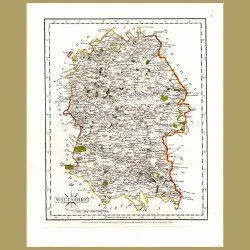
34.5 x 25.5 cm (13.5 x 10 inches).This original antique engraving was made in 1787. It is from a 'New and Correct English Atlas' by John Cary. It was made by copper plate engraving on medium weight, chain-linked cotton rich paper with original hand painted outline colouring. It is in good condition ..
USD100.00
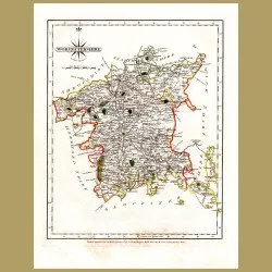
34.5 x 25.5 cm (13.5 x 10 inches).This original antique engraving was made in 1787. It is from a 'New and Correct English Atlas' by John Cary. It was made by copper plate engraving on medium weight, chain-linked cotton rich paper with original hand painted outline colouring. It is in good condition ..
USD100.00

49 x 37 cm (19 x 14.5 inches)This detailed colour map by William and Keith Johnston was published at the end of the 19th century in London and Edinburgh. It is a genuine antique, not a reproduction and is in very good condition.This is a double page lithograph, on medium weight creamy toned paper. T..
USD105.00

16.5 x 9 cm (6 x 3.5 inches).This original antique engraving was made in 1732 for a work by Noel-Antoine Pluche, "Spectacle De La Nature". This included hand made engravings about natural history, the heavens and science. The engravings we are offering are from the rare first French edition. It was ..
USD50.00

47 x 32 cm (18.5 x 12.5 inches).This beautiful, large map is from the last decorative hand colored atlas from England, The The Royal Illustrated Atlas Of Modern Geography, which was published in 27 parts from 1854-62 by A. Fullarton and Company of London and Edinburgh. It was printed via steel plate..
USD115.00

16.5 x 9 cm (6 x 3.5 inches).Le Navigation Du NordThis original antique engraving was made in 1732 for a work by Noel-Antoine Pluche, "Spectacle De La Nature". This included hand made engravings about natural history, the heavens and science. The engravings we are offering are from the rare first Fr..
USD50.00

68.5 x 53.5 cm (26.7 x 21 inches)Inset maps of the Straits of Gibraltar, the Dardanelles, the Bosphorus and CyprusThis large detailed colour map by George Philip was published in 1890 in London and Liverpool. It is a genuine antique, not a reproduction and is in very good condition.This is a double ..
USD115.00

47 x 32 cm (18.5 x 12.5 inches).Scilly Isles; Isle of Man; General Map of Channel Islands; Alderney, Guernsey and Jersey.This beautiful, large map is from the last decorative hand colored atlas from England, The The Royal Illustrated Atlas Of Modern Geography, which was published in 27 parts from 18..
USD115.00

68.5 x 53.5 cm (26.7 x 21 inches)From the Arctic Ocean to the Black SeaThis large detailed colour map by George Philip was published in 1890 in London and Liverpool. It is a genuine antique, not a reproduction and is in very good condition.This is a double page lithograph, on medium weight creamy to..
USD115.00

47 x 32 cm (18.5 x 12.5 inches).This beautiful, large map is from the last decorative hand colored atlas from England, The The Royal Illustrated Atlas Of Modern Geography, which was published in 27 parts from 1854-62 by A. Fullarton and Company of London and Edinburgh. It was printed via steel plate..
USD115.00

47 x 32 cm (18.5 x 12.5 inches).River Tyne, Hartlepool, Whitby, HullThis beautiful, large map is from the last decorative hand colored atlas from England, The The Royal Illustrated Atlas Of Modern Geography, which was published in 27 parts from 1854-62 by A. Fullarton and Company of London and Edinb..
USD175.00

47 x 32 cm (18.5 x 12.5 inches).Liverpool,This beautiful, large map is from the last decorative hand colored atlas from England, The The Royal Illustrated Atlas Of Modern Geography, which was published in 27 parts from 1854-62 by A. Fullarton and Company of London and Edinburgh. It was printed via s..
USD115.00

47 x 32 cm (18.5 x 12.5 inches).Inset of Nuremberg, Munich, FrankfurtThis beautiful, large map is from the last decorative hand colored atlas from England, The The Royal Illustrated Atlas Of Modern Geography, which was published in 27 parts from 1854-62 by A. Fullarton and Company of London and Edin..
USD115.00

26 x 21.25cm (10.5 x 8.25 inches ).Including an inset of the Shetland IslesThis antique engraving was made in 1824 and is from "A New And Complete System Of Universal Geography, Or An Authentic History And Interesting Description Of The Whole World And Its Inhabitants" by Christopher Kelly for the f..
USD115.00

26 x 21.25cm (10.5 x 8.25 inches ).Including an inset of CorsicaThis antique engraving was made in 1824 and is from "A New And Complete System Of Universal Geography, Or An Authentic History And Interesting Description Of The Whole World And Its Inhabitants" by Christopher Kelly for the firm of Thom..
USD115.00

26 x 21.25cm (10.5 x 8.25 inches ).This antique engraving was made in 1824 and is from "A New And Complete System Of Universal Geography, Or An Authentic History And Interesting Description Of The Whole World And Its Inhabitants" by Christopher Kelly for the firm of Thomas Kelly and was printed by R..
USD60.00

41 x 26cm (16 x 10.5 inches ).Large folding map rom the Netherlands to RussiaThis antique engraving was made in 1824 and is from "A New And Complete System Of Universal Geography, Or An Authentic History And Interesting Description Of The Whole World And Its Inhabitants" by Christopher Kelly for the..
USD60.00

43 x 26 cm (17 x 10 inches ).Folding map showing Greece and all its islandsTransylvania, Cyprus and the corner of ItalyThis antique engraving was made in 1824 and is from "A New And Complete System Of Universal Geography, Or An Authentic History And Interesting Description Of The Whole World And Its..
USD115.00

42 x 27cm (16.5 x 10.5 inches ).Folding map from the North Sea to SwitzerlandThis antique engraving was made in 1824 and is from "A New And Complete System Of Universal Geography, Or An Authentic History And Interesting Description Of The Whole World And Its Inhabitants" by Christopher Kelly for the..
USD115.00

49 x 37 cm (19 x 14.5 inches)This detailed colour map by William and Keith Johnston was published at the end of the 19th century in London and Edinburgh. It is a genuine antique, not a reproduction and is in very good condition.This is a double page lithograph, on medium weight creamy toned paper. T..
USD105.00

38.8 x 27.8 cm (14.5 x 10.9 inches)with map of Belfast and Lakes of Killarney on the backThis detailed colour map by George Franklin Cram was published in the 1890's in New York. It is a genuine antique, not a reproduction and is in very good condition.This is a lithograph, on medium weight paper wi..
USD80.00

38.8 x 27.8 cm (14.5 x 10.9 inches)with map of Naples on the backThis detailed colour map by George Franklin Cram was published in the 1890's in New York. It is a genuine antique, not a reproduction and is in very good condition.This is a lithograph, on medium weight paper with a map on one side and..
USD80.00

38.8 x 27.8 cm (14.5 x 10.9 inches)with plan of Dundee and map of Glasgow on the backThis detailed colour map by George Franklin Cram was published in the 1890's in New York. It is a genuine antique, not a reproduction and is in very good condition.This is a lithograph, on medium weight paper with a..
USD80.00