


Discover the charm of antique maps.
Antique maps are maps made over 100 years ago.
They are snapshots in time of our knowledge of the world.
Map making began in earnest in the Age of Exploration. This started in the 15th century.
As explorers roamed the world, they filled in open spaces on maps. As time passed, coastlines and interior details became more accurate.
Antique maps are eye-catching focal points for any room. They have historical and investment value lacking in modern reproductions.
Choose from our huge collection of antique maps. All maps we offer are genuine antiques.


32 x 25.5cm (12.5 x 10 inches). This is an original sepia toned steel engraved map from a work by James Sprent Virtue and was made in 1858. It is a genuine antique print, not a reproduction and is in good condition. This a double page map so has a fold line down the centre...
USD85.00

32 x 25.5cm (12.5 x 10 inches). This is an original sepia toned steel engraved map from a work by James Sprent Virtue and was made in 1858. It is a genuine antique print, not a reproduction and is in good condition. This a double page map so has a fold line down the centre...
USD85.00

32 x 25.5cm (12.5 x 10 inches). This is an original sepia toned steel engraved map from a work by James Sprent Virtue and was made in 1858. It is a genuine antique print, not a reproduction and is in good condition. This a double page map so has a fold line down the centre...
USD85.00

32 x 25.5cm (12.5 x 10 inches). This is an original sepia toned steel engraved map from a work by James Sprent Virtue and was made in 1858. It is a genuine antique print, not a reproduction and is in good condition. This a double page map so has a fold line down the centre...
USD85.00
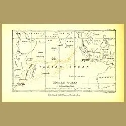
22.5 x 15 cm (9 x 6 inches).. The Indian Ocean by William Shore. Directions of flow of pumice after eruption of Krakatoa in 1883This original antique lithograph was made in 1890. It is from a work by A. D Frederickson, a Fellow of the Royal Geographic Society. This intrepid chap travelled from Londo..
USD50.00

49 x 37 cm (19 x 14.5 inches)This detailed colour map by William and Keith Johnston was published at the end of the 19th century in London and Edinburgh. It is a genuine antique, not a reproduction and is in very good condition.This is a double page lithograph, on medium weight creamy toned paper. T..
USD105.00

38.8 x 27.8 cm (14.5 x 10.9 inches)with map of Belfast and Lakes of Killarney on the backThis detailed colour map by George Franklin Cram was published in the 1890's in New York. It is a genuine antique, not a reproduction and is in very good condition.This is a lithograph, on medium weight paper wi..
USD80.00

38.8 x 27.8 cm (14.5 x 10.9 inches)With map of Milwaukee and Bayview, Wis. on the backThis detailed colour map by George Franklin Cram was published in the 1890's in New York. It is a genuine antique, not a reproduction and is in very good condition.This is a lithograph, on medium weight paper with ..
USD80.00

38.8 x 27.8 cm (14.5 x 10.9 inches)with map of Cleveland on the backThis detailed colour map by George Franklin Cram was published in the 1890's in New York. It is a genuine antique, not a reproduction and is in very good condition.This is a lithograph, on medium weight paper with a map on one side ..
USD80.00

38.8 x 27.8 cm (14.5 x 10.9 inches)with map of Naples on the backThis detailed colour map by George Franklin Cram was published in the 1890's in New York. It is a genuine antique, not a reproduction and is in very good condition.This is a lithograph, on medium weight paper with a map on one side and..
USD80.00

38.8 x 27.8 cm (14.5 x 10.9 inches)with map of Buffalo on the backThis detailed colour map by George Franklin Cram was published in the 1890's in New York. It is a genuine antique, not a reproduction and is in very good condition.This is a lithograph, on medium weight paper with a map on one side an..
USD80.00

38.8 x 27.8 cm (14.5 x 10.9 inches)with map of Toledo on the backThis detailed colour map by George Franklin Cram was published in the 1890's in New York. It is a genuine antique, not a reproduction and is in very good condition.This is a lithograph, on medium weight paper with a map on one side and..
USD80.00

38.8 x 27.8 cm (14.5 x 10.9 inches)with plan of Dundee and map of Glasgow on the backThis detailed colour map by George Franklin Cram was published in the 1890's in New York. It is a genuine antique, not a reproduction and is in very good condition.This is a lithograph, on medium weight paper with a..
USD80.00

38.8 x 27.8 cm (14.5 x 10.9 inches)with map of St. Louis on the backThis detailed colour map by George Franklin Cram was published in the 1890's in New York. It is a genuine antique, not a reproduction and is in very good condition.This is a lithograph, on medium weight paper with a map on one side ..
USD80.00

38.8 x 27.8 cm (14.5 x 10.9 inches)with map of Valetta, Valencia and Copenhagen on the backThis detailed colour map by George Franklin Cram was published in the 1890's in New York. It is a genuine antique, not a reproduction and is in very good condition.This is a lithograph, on medium weight paper ..
USD80.00

38.8 x 27.8 cm (14.5 x 10.9 inches)with map of Nashville on the backThis detailed colour map by George Franklin Cram was published in the 1890's in New York. It is a genuine antique, not a reproduction and is in very good condition.This is a lithograph, on medium weight paper with a map on one side ..
USD80.00

38.8 x 27.8 cm (14.5 x 10.9 inches)with map of St. Paul on the backThis detailed colour map by George Franklin Cram was published in the 1890's in New York. It is a genuine antique, not a reproduction and is in very good condition.This is a lithograph, on medium weight paper with a map on one side a..
USD80.00

38.8 x 27.8 cm (14.5 x 10.9 inches)with map of Atlanta on the backThis detailed colour map by George Franklin Cram was published in the 1890's in New York. It is a genuine antique, not a reproduction and is in very good condition.This is a lithograph, on medium weight paper with a map on one side an..
USD80.00

38.8 x 27.8 cm (14.5 x 10.9 inches)with map of Council Bluffs on the backThis detailed colour map by George Franklin Cram was published in the 1890's in New York. It is a genuine antique, not a reproduction and is in very good condition.This is a lithograph, on medium weight paper with a map on one ..
USD80.00

38.8 x 27.8 cm (14.5 x 10.9 inches)with map of Stockholm on the backThis detailed colour map by George Franklin Cram was published in the 1890's in New York. It is a genuine antique, not a reproduction and is in very good condition.This is a lithograph, on medium weight paper with a map on one side ..
USD80.00

38.8 x 27.8 cm (14.5 x 10.9 inches)with map of Vienna on the backThis detailed colour map by George Franklin Cram was published in the 1890's in New York. It is a genuine antique, not a reproduction and is in very good condition.This is a lithograph, on medium weight paper with a map on one side and..
USD80.00

38.8 x 27.8 cm (14.5 x 10.9 inches)with map of Montreal on the backThis detailed colour map by George Franklin Cram was published in the 1890's in New York. It is a genuine antique, not a reproduction and is in very good condition.This is a lithograph, on medium weight paper with a map on one side a..
USD80.00

49 x 37 cm (19 x 14.5 inches)This detailed colour map by William and Keith Johnston was published at the end of the 19th century in London and Edinburgh. It is a genuine antique, not a reproduction and is in very good condition.This is a double page lithograph, on medium weight creamy toned paper. T..
USD105.00

49 x 37 cm (19 x 14.5 inches)This detailed colour map by William and Keith Johnston was published at the end of the 19th century in London and Edinburgh. It is a genuine antique, not a reproduction and is in very good condition.This is a double page lithograph, on medium weight creamy toned paper. T..
USD175.00

24.5 x 30 cm (9.5 x 12 inches).Double sized folding printThis antique print about Pompeii is by Sir William Gell and was made in 1817. Pompeii was a city near Naples, buried by ash by a volcano in 79AD. This is an original antique print made by steel engraving, not a reproduction. It is in excellent..
USD40.00

56 x 47 cm (22.5 x 18.5 inches).Includes states of TX, LO, MS, ARFoldout mapThis beautiful, large map is from the last decorative hand colored atlas from England, The The Royal Illustrated Atlas Of Modern Geography, which was published in 27 parts from 1854-62 by A. Fullarton and Company of London a..
USD115.00

56 x 47 cm (22.5 x 18.5 inches).Includes states of MS,AL,TN,GA,NC,SC and part of FL, VI, KYFoldout mapThis beautiful, large map is from the last decorative hand colored atlas from England, The The Royal Illustrated Atlas Of Modern Geography, which was published in 27 parts from 1854-62 by A. Fullart..
USD115.00

56 x 47 cm (22.5 x 18.5 inches).MI, IL, WI, IN, NE, MI, IA, IN, NE, MNFoldout mapThis beautiful, large map is from the last decorative hand colored atlas from England, The The Royal Illustrated Atlas Of Modern Geography, which was published in 27 parts from 1854-62 by A. Fullarton and Company of Lon..
USD115.00

56 x 47 cm (22.5 x 18.5 inches).Includes NH,ME,VT,NY,MA,RI,CT,NJ,de,MD,PA,OH,VA,MIFoldout mapThis beautiful, large map is from the last decorative hand colored atlas from England, The The Royal Illustrated Atlas Of Modern Geography, which was published in 27 parts from 1854-62 by A. Fullarton and Co..
USD115.00

56 x 47 cm (22.5 x 18.5 inches).Also shows Queen Charlotte Sound and part of AlaskaFoldout mapThis beautiful, large map is from the last decorative hand colored atlas from England, The The Royal Illustrated Atlas Of Modern Geography, which was published in 27 parts from 1854-62 by A. Fullarton and C..
USD115.00